I’ve been crazy busy the past few days: enjoying a four day weekend at home with my wife and daughters, trying to see many of our Twin Cities friends one last time before we head first West then East (then probably west again), staying up too late Sunday and Monday night watching all of Arrested Development Season 4 (my wife and I finished the last three episodes this morning), trying to sell or give away furniture we’re not bringing to Massachusetts, finding a place to live in Boston, and of course preparing for tonight’s ArchiCAD Minnesota User Group where I’ll be showing off ArchiCAD 17.
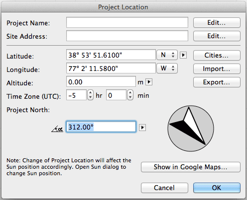
In an effort to smash some of that stuff together, tonight I want to show how someone can set the elevation above sea level, latitude, and longitude of their project in ArchiCAD 17 and then show the model in Google Earth. And of course what better location to show off than where I’ll be living in Boston? Now I have the address, but how does one find the elevation, latitude, and longitude of a particular spot on the Earth? Well this is 2013, so it’s insanely easy.
I used this website: Veloroutes.org/elevation/, and I’d wager there are plenty of others that do the same thing. All I needed to do was type in my new address and I got all the information I needed. Then it was as simple as going into ArchiCAD, opening up project location and inputting the numbers in the right spot. Done.

So that’s cool. Just a few clicks and I can get pretty good data for just about any construction site that Google has information on. Which let’s be honest, is pretty much every construction site…
The Google Earth Part
In lieu of writing about the ArchiCAD into Google Earth connection, here’s a video that walks you through the process:
Getting this data into your BIM is important. Site Information is the foundation of not just understanding your model in a larger visual, spacial, and psychological context, it’s also the bedrock for energy modeling. So think of adding elevation, longitude, and latitude into your file as the start of both design and energy analysis.
If my youngest Daughter would only sleep later than 4:55 am, I’d have something witty to say here. Follow Shoegnome on Facebook and Twitter so that you don’t miss out. And while you’re at it, the RSS feed is lonely and could use more subscribers.
7 thoughts on “Simple Solutions: Elevation, Latitude, and Longitude”
Does this work in AC16?
Peter, yes. The only part that is different in ArchiCAD 17 is the Google Earth Connection. You can read more about how that works in ArchiCAD 16 here.
Thanks Jared
Nice tip.
Now I know how high above the ocean we live, 72′.
logan
🙂
I’m moving from 938 ft down to 137 ft.
Very cool – thanks for sharing this easy method to get site information!
Eric
It says I’m a 59′, I think I’m actually a 7′. But I wish I was a 59′:
http://tinyurl.com/kafryl2
Greg
52′ margin of error… I guess when you’re in the mountains that’s pretty good. 😉